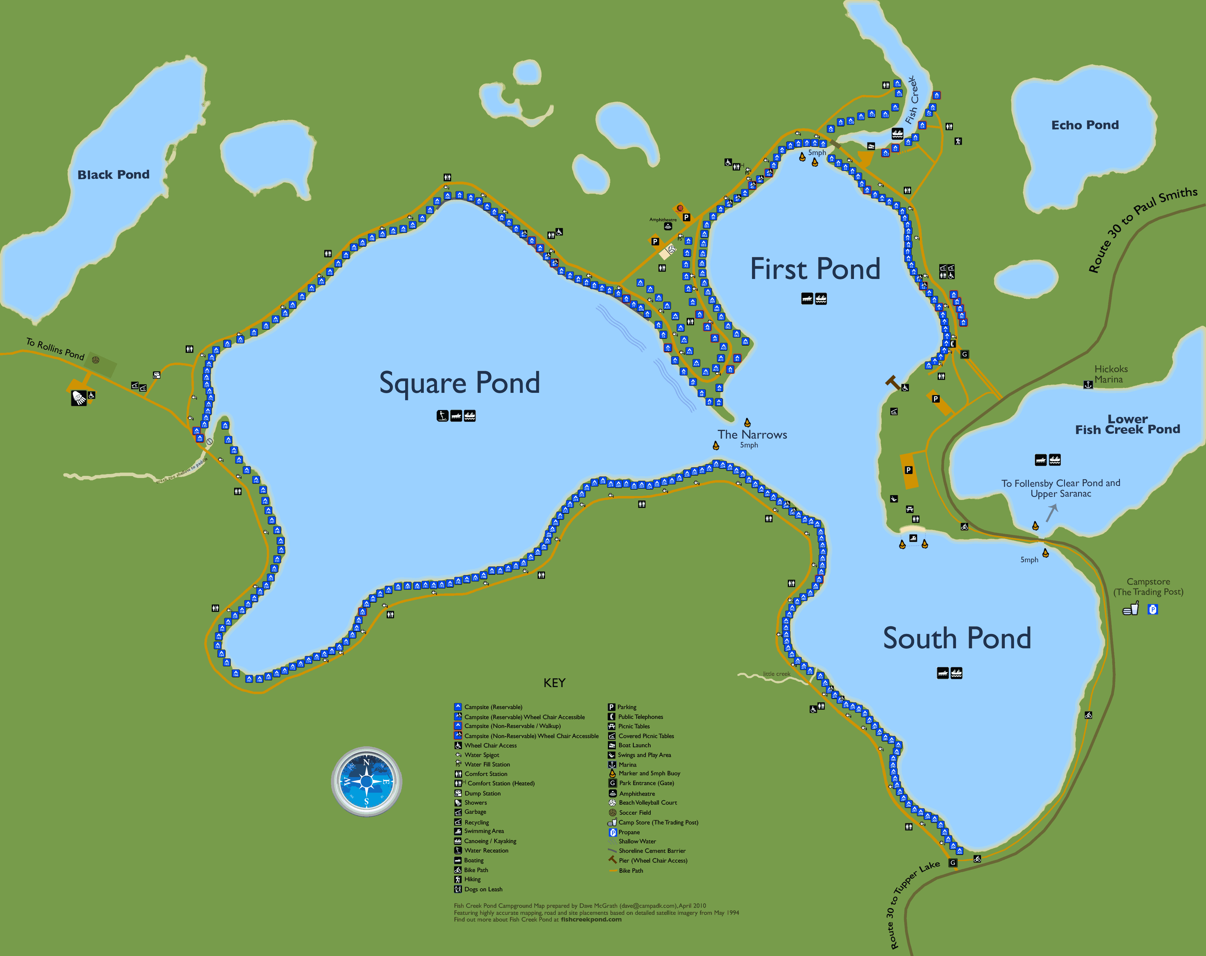
Welcome to the NEW Fish Creek Pond map. This map is VERY accurate. Each campsite is in the exact location indicated. Click on top links to access specific areas of the campground. You can also use your mouse to scroll the map or zoom/in out, or simply use the the zoom/in buttons. Not sure what a symbol means? Simply click on Legend.
Map prepared by Dave McGrath, April 2009. Map based on detailed satellite imagery from May 1994.
Fish Creek Campground Map prepared by Dave McGrath dave@campadk.com,
Featuring highly accurate mapping, road and site placements based on detailed satellite imagery from May 1994.
First Pond - The closest pond to the main entrance. The canoe route up Fish Creek is located here at the northeast corner of First Pond. The boat ramp is also located here, just past the bridge.
First Pond is a bit quieter than its active big brother, Square Pond. First Pond is also protected a bit more than Square Pond on windy days.The first group of sites from 1W to about site 25 are somewhat smaller sites compared to other areas. As well, trees scattered about these sites make it more difficult for trailers to camp in this area. Sites 26-34 are much larger and trailer friendly. Sites 35-64 are much more spacious and provide excellent morning sun exposure. Sites centered around site 50 are in close proximity to the amphitheater. Sites 51-64 are located on the peninsula with the advantage of much less traffic passing by the campsites.
First Pond - Sites 1W-18 are close to the main gate and typically smaller in size with many trees within the campsite area which can be challenging for larger trailers. This area is quite shady and can be subject to winds from across First Pond. They is substantial traffic in this area (Sites 4-18) as all Fish Creek and Rollins Pond campers have to pass through this section.
Pros: close to main gate with easy access to paddling up into Fish Creek. Sites 1W-3 enjoy less traffic.
Cons: High through traffic in this area and sites tend to be less suited for larger trailers.
First Pond - Sites 19-34 are close to the main gate and tend to be larger in size than 1W-18. Sites 27-34 are quite deep. There is substantial traffic in this area as all Fish Creek and Rollins Pond campers have to pass through this area. This effect is less noticeable for sites 27-34 due to their depth. These sites are also close to the boat launch and Fish Creek itself.
Pros: close to main gate with easy access to paddling up into Fish Creek. Close to boat launch. Sites 27-34 are quite deep and large.
Cons: High through traffic in this area, along with boat launch activity.
First Pond - C Section is located on Fish Creek itself. This is the stream that feeds into First Pond. Sites in this area are NOT on any of the main ponds. They are somewhat private, at least as far as drive by traffic goes. Most sites are more suited to tents or small trailers. They tend to be fairly high off the water and most provide water access although it requires a steep descend down to the water. Motor boats are still allowed at this sites however you may only go downstream from here, under the bridge and into First Pond. You can of course canoe or kayak in either direction.
Pros: quietest area in the campground, off the main road so there is little traffic, more private than the main ponds, easy access up into Fish Creek.
Cons: most sites are more suited to tents or small trailers, not as desirable for those participating in boating activities (water skiing, tubing etc), sites are higher off the water with steep access to shoreline, no beach areas at campsites.
First Pond - Sites 35-50 are still fairly close to the main gate as well as access up Fish Creek and the boat launch. They also enjoy fairly close proximity to the amphitheatre. There is considerable drive through traffic past these sites. Sites 39-46 are quite large and many feature the larger granite fireplaces. This area features the only heated bathroom in the campground. This is the only seciton of the campground that is open in early season (ie April). This area tends to be less subject to wind than sites in the 1W-34 range.
Pros: close to amphitheatre, Fish Creek, the boat launch and still fairly close to the main gate. Many have large granite fireplaces (39, 40, 41, 42 and 46), access to the only heated bathroom.
Cons: drive by traffic, especially for some sites that are very close to the road (Sites 35 and 48-50).
First Pond - Sites 51-64 are located on the peninsula, away from the heavy through traffic. These sites are close to the amphitheatre and have easy access up into Fish Creek. Some sites in this area tend to be higher off the water than other sites. Some shorelines have been fitted with log staircases to prevent erosion.
Pros: greatly reduced traffic compared to other areas of the campground, great morning sun, less shady than other areas, close proximity to the amphitheatre, volleyball and basketball nets, and easy access up into Fish Creek for paddlers
Cons: some sites are higher off the water (sites 51-58) than others which may be less desirable for those with smaller children
Square Pond - The largest and most active of the 3 ponds. It provides the best shoreline views of any of the ponds. Mountain views are enjoyed from sites on the north shore, as well as some sites on the western shore. Even Whiteface Mountain can be seen from some sites on the western shore! Square Pond is the choice for active families who enjoy watersports. Those who enjoy a quieter experience or who have canoes and kayaks may prefer to be on one of the other ponds. Sites on the north and west enjoy great morning sun. Those on the eastern and south east shores will enjoy fine sunsets. Note: sites 65 and 66 are actually on First Pond.
Square Pond - Sites 65-80 are located along the west coast of the peninsula facing west across Square Pond. These sites are subject to more wind on average than any other areas at Fish Creek. This area was once the original beach and as such, the shoreline is quite shallow for well over 50 feet from shore. Great for swimming, less desirable for mooring boats. This area is away from through traffic and enjoys fairly close proximity to the amphitheatre. Sites at the tip of the peninsula are large and more private than others.
Pros: a quieter area with some private sites at the end of the peninsula, great shallow beach from about site 68 to site 80, fine sunset views.
Cons: subject to considerable more wind than other areas in the campground, less desirable for those with motor boats due to shallow water depth.
Square Pond - Sites 81-100 are located on the largest of the three ponds. Sites 81-100 on average receive more wind than any other area on the campground. Sites 80 to about site 96 enjoy fine sunsets. Sites 80 to about site 87 are quite shallow out to at least 50 feet from shore. Site 87 has a long very shallow finger than extends well over 100 ft from shore which can be hazardous for motor boats.
Pros: Sites in the 80's are close to the amphitheatre, excellent afternoon sun, great area for sunset and views across Square Pond, shallow water between sites 80 and approx 87.
Cons: high through traffic as most sites are adjacent to the road (ie not deep), windiest area in the campground, smaller sites especially between site 80 and 90, shallow for boat between site 80 and 87.
Square Pond - Sites 101-119 are located on the north shore of Square Pond. These sites enjoy all day sun and most offer fine panoramic views looking south across Square Pond with the mountains in the background. Sites 102-105 have very open shorelines and are sometimes referred to as 'the lawns' due to the nature of their waterfronts. These sites can be windy at times.
Pros: most sites in this area are quite open with fine views, and all day sun.
Cons: considerable traffic, can be windy at times
Square Pond - Sites 120-137 are located just before the cutoff to Rollins. As such they still receive considerable drive by traffic. Sites 126-137 are encompassed in tall pines and as such are very shady. During hot summer days these sites can on occasion be subject to odours from the nearby dump station. Sites 126-133 tend to be somewhat narrow with less buffer between neighbours than other areas of the campground. This section is the closest to the shower complex and the soccer field.
Pros: close to the showers, protected from the wind.
Cons: very shady, Site 126-133 are very narrow, may be subject to odours from the nearby dump station.
Square Pond - Sites 138-149 are located on the west shore of Square Pond just after the Rollins Pond cutoff. As such traffic is less than lower numbered sites. This area is often referred to as the 'golden coast' (mainly due to sites 143 and 144). Sites tend to be quite deep and extra large with decent privacy from neighbours due to size and treed perimeters. sites 143 and 144 have fine beaches. Many have a great view looking east with a view of Whiteface Mountain in the distance. These sites enjoy morning sun.
Pros: extra large and often deep sites with morning sun, many have fine mountain views and a few have fine beach areas, less prone to wind.
Cons: farthest sites from either the front or back gates, long paddle to get up into Fish Creek.
Square Pond - Sites 150-159 are located on the west shore of Square Pond and face south east looking across at sites on the other side of the west bay. These sites are fairly large and wide and are subject to some noise due to the wooden retaining wall on the opposite side of the road. These sites tend to encounter more water traffic as boats swing around the bay and back out onto Square Pond during peak summer months.
Pros: mainly large sites, protected from wind
Cons: noise from retaining wall, far from either front or back gate, long paddle to get up into Fish Creek.
Square Pond - Sites 160-179 are located at the end of the south west bay on Square Pond. These sites are well protect from any wind. Sites 162-167 are sloped somewhat, especially sites 166 and 167 which may be an issue for those with larger trailers. Sites 166 and 167 are quite open and thus sunny. Sites 164, 165 and 166 are a bit higher off the water than other sites.
Pros: ideal for those that prefer to be in a protected bay away from boat traffic passing by (Sites 160 to about 174 at least), nice night-time ambience with views of lite fireplaces across the bay.
Cons: some sites are sloped in this area (162-167).
Square Pond - Sites 180-199 are located on the south west shore of Square Pond looking north. These sites are fairly well protect from the wind and enjoy day time and late day sun shine along with sunsets. Most are treed in birch and as such receive more sun that other areas. Most sites, at least from site 180 and up are quite large. Some such as 186 and 187 have a nice although eroded beach area along with a panoramic shoreline view.
Pros: mainly large open and sunny sites.
Cons: Fairly distance from either front or back gates.
Square Pond - Sites 200-215 are fairly large sites within an area of birch, thus tend to receive more sun than some other areas. These sites face north to north west across Square Pond and receive afternoon and late day sun. Many have partially obstructed shoreline views. Sunset views are available from most sites.
Pros: fairly large, level and sunny sites
Cons: more shrubbery along the waterfront than some other areas.
Square Pond - Sites 216-230 are located on the south shore of Square Pond somewhat close to the narrows. Most sites are quite large, and offer fine views looking north upon Square Pond. They are a mix of shady as well as more open, sunny sites. They offer a Square Pond location for boating activities as well as being close enough to paddle across the narrows and up into Fish Creek.
Pros: fairly large sites, many being quite sunny, afternoon sun, sunset views.
Cons: Sites 217-220 tend to gather water during rainy periods, water can be shallow off of some sites which may be an issue for mooring boats.
Peninsula - This area is located on the land that separates First Pond from Square Pond. It includes sites 50-79 and well as the inland sites, A1-A22. This is a great area if you want to be away from the heavy thru traffic that passes through the park. Sites here are also close to the amphitheatre, basketball court and volleyball court which is great for those with kids.
Peninsula - Sites A1-22 are located off water on the inside of the peninsula loop. These sites tend to be fairly large amongst large tall pines, and offer a quieter experience away from through traffic. They are a great choice for those who do not wish or are not bothered to be off water. A section provides easy access to the amphitheater, volleyball and basketball courts.
Pros: away front through traffic, close to amphitheater, volleyball and basketball courts, many are quite large.
Cons: not on water
The Narrows - Located between Square Pond and First Pond on the southern shore. Boats will be passing by your site somewhat slower since there is the 5mph limit through the narrows at the tip of the peninsula. Head straight up into First Pond to paddle up into Fish Creek or head to the south and under the bridge over Route 30 to access Floodwood Pond or Upper Saranac. Sites in this area are generally protected on windy days and enjoy the early morning sun.
The Narrows - Sites 231-250 are located at the narrows where Square Pond meets First Pond. This area receives substantial boat traffic through the narrows, however there is a 5mph speed limit in this area. Most sites are fairly large and sunny.
Pros: fairly large and sunny sites with easy access to all three ponds as well as a short paddle to get up into Fish Creek,
Cons: substantial pass by boat traffic.
South Pond - The last pond on the drive all the way around the campground. South Pond can be easily accessed via the back gate located at site 305 during summer months. This is the quietest of the 3 ponds and there is much less thru traffic past campsites in this area. Subjected to some noise however from traffic across the pond on Route 30. Sites at the north end of South Pond look across towards the park beach area while the sites a bit farther south look across towards the bridge over Route 30.
South Pond - Sites 251-270 are located on the west shore of South Pond. These sites receive excellent morning sun. This pond tends to be the quietest of the 3 ponds although boat traffic from the other ponds do head through South Pond to head up to Lower Fish Creek Pond as well as Upper Saranac Lake. Sites in the 250 range tend to be larger than sites in the 260-270 range. SItes 250-257 look due east with a view of the park beach.
Pros: larger sites in the 250's, morning sun, a bit quieter than sites on the other ponds, easy exit via the back gate during peak season
Cons: considerable boat traffic pass by sites 250 to about 254, a long drive out when the back gate is closed (non peak season).
South Pond - Sites 271-288 face north east looking out upon South Pond, the park beach and the bridge over Route 30. These sites receive minimal noise from car traffic across the pond. Sites here enjoy morning sun and less boat traffic than the other 2 ponds. Sites 265 and 266 are fairly small with some slope. Sites 287, 288 and 289 are extra deep.
Pros: quiet area, sites are quite level with waterline, morning sun, close to back gate during peak season when it is open.
Cons: some sites are fairly small, a few tend to hold water during rainy periods, a long drive out when the back gate is closed (non peak season).
South Pond - Sites 289-305 face north east looking across the far end of South Pond. These sites provide easy access out of the campground during peak season when the far gate is open. This area receives the least amount of boat traffic, and enjoys morning sun. Sites here will encounter some noise from the car traffic on Route 30. Sites here are the closest for boating up into Upper Saranac, and are the closest to the marina and park store.
Pros: one of the quieter sections out on the water, closest area to access Upper Saranac, the marina and the park store, quick access in and out of the campground during summer months.
Cons: noise from car traffic on Route 30, long drive out when the far gate is not open, longer paddle to head up into Fish Creek.
The Main Gate - is located just off Route 30. During the spring and fall seasons this is often the only entrance in and out of the campground. During summer months the back gate is open between the periods of 8am-8pm. On busy weekends and peak periods during the summer, there can be long line ups at the main gate for new arrivals.
The Back Gate is a quick way to get in and out of the park if you are camping on the south shore of Square Pond, the Narrows or South Pond. The gate is open 8am-8pm, but only during summer months.
The showers consist of a shower building which serves all campers at Fish Creek. Not to worry however, there are 30 showers on the womens side and 30 more on the mens side. The shower building is rarely overly busy. Don't forget to bring a few quarters to feed the shower meters (25 cents for 5 minutes). if you are camping closer to the front entrance or the far exit you'll likely want to bike (or drive) to the showers due to the distance.
The boat launch is located across from site 31 on First Pond. It will accommodate pretty much any boat, even pontoon boats and has a decent ramp! There is no parking here, so you'll have to have someone drive your vehicle and trailer back to your campsite once you put your boat in. Motorboats are NOT allowed to go upstream into Fish Creek. Head out under the bridge to the left and out into First Pond. Note! The water is quit shallow until you get out aways into First Pond. Keep your trim up and speed down in this area! Also be aware of the many canoes and kayaks that may be travelling up into or out of Fish Creek. The boat launch area is a popular spot for kids to fish.
The amphitheatre is where activities staff put on many great shows all summer long for campers at the amphitheatre. The amphitheare is nestled amongst the tall pine trees at the north end of the peninsula. Those camping from about site 45 through site 86 as well as A1-A22 will be close to all the activities that happen here including some of the kids activity program, beach volleyball, night time musical events by local musicians, educational programs and much more. There is also a basketball net here for the teens.
The camp store (The Trading Post) is a completely stocked store and gas station. Owner 'Phil' can provide you with all the camping supplies you may need as well as groceries including fresh meats, pizza, ice, beer, wine
coolers and firewood. There is also an ice cream booth outside the store. Gas must be prepaid here. There is also an ATM machine inside. The Trading Post is open from Memorial Day weekend through to the Columbus Day. The store is easily accessible by foot for those camping at either end of the campground. Otherwise there is the bike path that connect the front and back gates along the west side of Route 30 (or your can drive). You can access the camp store from water by bringing your canoe, kayak or boat up to the shore across the road on South Pond and then crossing the road over to the camp store. (there is no dock here, however this area has a shallow sandy bottom).
The beach is the only 'official' area to swim at Fish Creek (although campers do wade out in the water by their site or float on watertoys) and is located on the north east shore of the South Pond. It is located to the left once you enter the park area. The water is fairly shallow here. There is a lifeguard on duty only during very busy periods. Water toys and floaties are not permitted at the beach. There is also a large day use area here with a play center and swings for the kids, picnic tables, barbeque stands and a covered picnic table area for groups. The beach area looks out across towards sites 255-270.
Marina needs are met by Hickocks Boat Livery located outside the park across the road on Route 30 on Lower Fish Creek pond. It can be access by boat by navigating under the bridge from the South Pond. This is the waterway that connects Fish Creek to Floodwood Pond and Upper Saranac Lake. Hickock's offers canoe, kayak and motor boat rentals, a fully stocked store for marine and fish supplies, bait, ice, fishing license and gas pumps on the docks.


 around the maps border
 magnifier icons
 to view individual campsite details, photos (forum members will also see availability)